The University of California, Riverside (UC Riverside) will develop artificial intelligence (AI) for UAS, using a $1 million grant from the National Science Foundation.
AI in UAS would one day allow the robots to conduct “far-reaching reconnaissance missions”— such as search and rescue missions, and environmental and security monitoring—without direct human control.
Amit Roy-Chowdhury, professor of electrical and computer engineering, and the principal investigator in the grant, would like to create programs that allow UAS to act on their own, such as by zooming in on a certain object.
Data
Data

Australian Institute of Marine Science uses Wave Glider USV to monitor Great Barrier Reef
The Australian Institute of Marine Science (AIMS) and Boeing recently used the Liquid Robotics-developed Wave Glider USV to complete a seven-day open water mission, which was the “first major milestone of a five-year joint research agreement” between the two companies.
The mission, which covered 200 nautical miles including parts of North Queensland’s Great Barrier Reef, showcased how the Wave Glider could evaluate the health of the coral reefs and ecosystems.

NOAA's UAS program director Robbie Hood retires
Robbie Hood, the UAS program director at the National Oceanic and Atmospheric Administration, has retired after three decades of government service.
Hood founded the UAS program at NOAA and led the introduction of unmanned systems to the agency, which has used them for years to better understand weather and improve forecasting.
According to NOAA, the Sensing Hazards with Operational Unmanned Technology (SHOUT) program was the highpoint of her career. SHOUT used NASA’s Global Hawk to study storms, including by using high-altitude dropsondes that could measure wind speed and other attributes within storms. SHOUT proved that using unmanned systems to aid in weather forecasting is feasible.
Geomni launches UAS service for property inspections
Geomni, which is a Verisk Analytics business that is centered around an “address- and location-based database of property-related analytics,” has announced a new service in which customers can dispatch a licensed, qualified UAS pilot to collect imagery and data about a structure.
Using the data collected during the UAS inspection, a Geomni Property data package is created. The package includes “ultrahigh-resolution imagery and 3D exterior roof and wall details that fully integrate with North America’s most widely used repair estimating system.”
The data collected during the inspection augments the data available from Geomni’s expansive database of imagery collected across the country by the company’s fleet of aircraft.
")
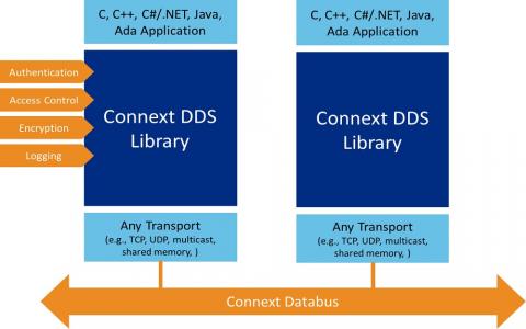
Real-Time Innovations announces connectivity software that can be used for autonomous vehicles
Industrial Internet of Things (IoT) connectivity company Real-Time Innovations (RTI) has announced its RTI Connext DDS 5.3, which is the “first connectivity software designed to build layered-databus architectures for IIoT systems of systems.”
Some of the features of RTI Connext DDS 5.3—which has a number of possible use cases, including with autonomous vehicles—include interoperable security, a historical data query, and seamless device mobility, which is especially important for autonomous vehicles because of how critical it is for systems to maintain connectivity even as devices roam across networks.
From Unmanned Systems: Jeopardy champ Watson branches out into business
Many people think of artificial intelligence as something all-consuming, a superior computer thinking ability that could make humans obsolete.
Decades of books, movies and TV shows have warned seems like an inevitable computer or robotic uprising, including the 1920 stage play, “Rossum’s Robots,” which gave us the term robot in the first place.
And tech industry leaders such as Mark Zuckerberg on Musk have been arguing lately about AI and whether it’s a force for good, as Zuckerberg posits, or an existential threat to humanity, as Musk says.

Hazon Solutions surpasses bridge inspection milestone using UAS
After being charged with the task of conducting the most comprehensive UAS-based inspections in the industry by Norfolk Southern back in early 2016, Virginia Beach-based Hazon Solutions has announced that it has inspected more than 100,000 linear feet of railway bridges.
Over the last year and a half, Hazon has conducted more than 64 complete bridge inspections across the eastern United States, which has left CEO and co-founder David A. Culler, Jr. CAPT USN (ret) extremely pleased.
“We're very proud to announce this remarkable milestone,” Culler says.

3D Robotics’ Site Scan now includes ground control points
3D Robotics (3DR) has announced that ground control points (GCPs) are now available to be processed in its Site Scan UAS data platform for engineering and construction.
GCPs are “easily-identifiable markers on the ground of a jobsite that can be used to ‘georeference’ drone maps and models,” which makes it possible to not only increase the absolute accuracy of UAS data, but also creates superior deliverables such as orthomosaics, point clouds, and more.
“Ground control points are a game-changer for Site Scan,” says Chris Swigert of Liberty Excavators.
“Now, I can easily tag and process GCPs in the cloud, and deliver my clients more accurate drone maps and models than ever before.”

Pioneer Aerial Surveys signs UAV-MAG contract to perform survey for Quantum Pacific Exploration
Starting in August, Pioneer Aerial Surveys, which is the wholly owned subsidiary of Global UAV Technologies, will conduct a survey for Quantum Pacific Exploration (QPX), after signing a UAV-MAG contract in Chile.
For Pioneer Aerial, this will be its third international survey, and its first contract for a UAV-MAG survey in South America.
“The QPX contract marks a significant step in Pioneer Aerial’s acceptance as the leader in UAV-MAG surveys worldwide,” says Michael Burns, President of Pioneer Aerial Surveys.