Date/Time: Wednesday, February 9 at 3:00 – 4:00 pm EST
Mapping
Mapping
Siemens Integrated Design Systems, A Collaborative, Modular Approach to Faster and More Accurate Digital Drone Prototypes
Date/Time: Wednesday, March 9 at 3:00 - 4:00 pm EST
Webinar Description: Join us as we look at the complex challenges associated with Drone Vehicle creation, and how Siemens Design Software enables your team to address these unique challenges and create digital prototypes faster and more accurately. We will discuss the Siemens Design ecosystem as it relates to:
Collaborative Product Design
Basic to Advanced Analysis of Drone systems, from Mechanical and Electrical, to Thermal and Aerodynamics
Industry leading Integrated approaches to traditional manufacturing as well as Additive Manufacturing technologies
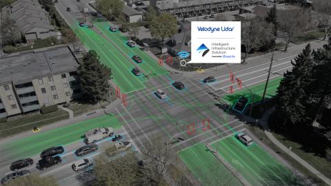
How Lidar Can Improve Safety, Efficiency
AUVSI and SAE International recently hosted the first Business of Automated Mobility Forum, bringing together industry leaders and experts from across the automated mobility industry to develop guiding strategies for success.
During an Enterprise Solutions Series presented by Jon Barad, VP of Business Development at Velodyne Lidar, Forum attendees learned about how lidar-based solutions are transforming infrastructure to make communities smarter and safer, today and in the future.
Black Swift Technologies contracts with NOAA to develop a backup navigation system for when standard GPS fails
Jamming. Spoofing. Interference from the landscape or cityscape. Interference from other flight equipment.
Such snarls arise often enough with satellite signals to make it clear: Routine UAS flight beyond the line of sight (BLOS) will likely never happen with traditional GPS technology alone. To assure safe travel over long distances, unmanned aircraft systems need greater capability to ensure accurate positioning and routing.

senseFly establishes itself as a leader in BVLOS operations
As beyond visual line of sight (BVLOS) UAS operations are primed to open a range of possibilities in the drone industry, fixed-wing drone solutions provider senseFly has established itself as an early leader in safely and successfully performing these operations.

TomTom launches new product to ensure safe automated driving operations
TomTom (TOM2) has launched a new product for automated vehicles called TomTom RoadCheck that allows carmakers to decide where it is safe for drivers to activate their vehicles’ automated driving functions.
Weekend Roundup: August 7, 2020
This Week in the Unmanned Systems and Robotics World
The National Oceanic and Atmospheric Administration (NOAA) and the U.S. Navy have signed a new agreement to jointly expand the development and operations of unmanned maritime systems in the nation’s coastal and world’s ocean waters. Through the agreement, NOAA will accelerate its science, service and stewardship mission by leveraging the Navy’s expertise, infrastructure, best practices and training. (NOAA)

Woolpert to develop strategic plan and concept of operations for Indiana's UAS program
The Indiana Department of Transportation (INDOT) has contracted Woolpert to develop a strategic plan and concept of operations for the state’s UAS program.
Momenta, Toyota partner to develop HD maps for autonomous vehicles
Momenta, which is building the “brain” for autonomous driving, has partnered with Toyota to provide automated HD mapping and updates through vision-based technologies.
To better serve Chinese customers, the companies will seek to use this joint development to promote the commercialization of Toyota’s Automated Mapping Platform (AMP) in the Chinese market.
Momenta’s vision-based, camera-based HD mapping uses low-cost consumer-grade sensor sets, which is made up of camera, GPS, and IMU to automatically generate HD maps with 10-centimeter level relative accuracy by using cutting-edge technologies such as deep-learning based perception and simultaneous localization and mapping (SLAM).

TRI-AD, Carmera announce new results from mapping exercises for autonomous vehicles
Toyota Research Institute-Advanced Development Inc. (TRI-AD) and Carmera Inc. have announced the new results from their ongoing partnership.
During the latest phase, commercially available dashboard-mounted cameras were used to detect key road features with the relative accuracy performance necessary for automated driving. Using a combination of Carmera’s technologies, key road features such as lane markings, traffic signals and signs were detected and placed along Michigan roadways in central Detroit and Ann Arbor.